FR
Sonya Isupova - Cartographie d'un paysage incertain
Témoigner des changements du paysage ukrainien : surveiller, suivre et cibler, schématiser, dessiner et redessiner les segments du terrain ukrainien à l'aide d'une machine à cartographier.
Tout a commencé par une carte. Depuis le début de l'invasion russe à grande échelle de l'Ukraine, les agences de presse mondiales, les services de renseignement, les cartographes indépendants et les journalistes d'investigation se sont penchés sur la carte. Tous cherchent à créer la carte la plus simple, la plus compréhensible et la plus attrayante visuellement pour expliquer les réalités complexes de cette guerre brutale et non provoquée. Pourtant, ces cartes sont truffées de pratiques réductionnistes qui tendent à simplifier et à effacer la réalité de ce qu'elles sont censées représenter. Ce projet s'inscrit dans le prolongement de mon mémoire de maîtrise intitulé "Mapping Uncertain Landscape", dans lequel j'ai analysé la cartographie moderne ukrainienne liée à la guerre en Ukraine et comparé diverses sources cartographiques. En explorant la question de la précision lors de la cartographie des incertitudes de la guerre, j'ai pu voir les problèmes et les alternatives possibles aux pratiques cartographiques modernes.
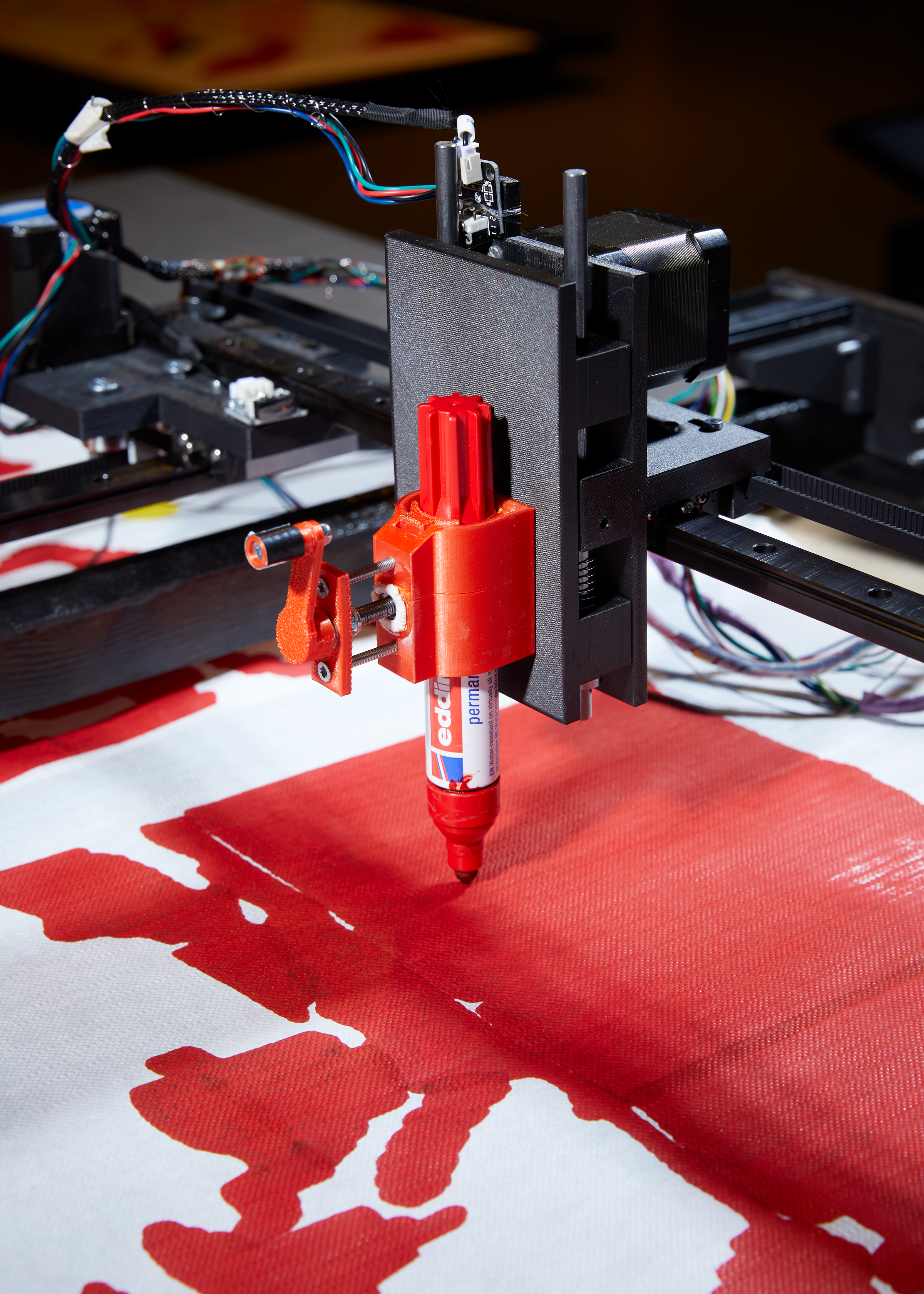
L'installation explore la relation entre l'homme et la machine, le cartographe et la carte. Elle examine de plus près les infrastructures de télédétection et leurs problèmes. Elle remet également en question les cartes et les processus de cartographie afin de percevoir les changements dans le paysage qui se produisent quotidiennement en raison de la guerre qui sévit actuellement en Ukraine. Sonya Isupova a construit une machine, un satellite métaphorique, planant au-dessus de la terre, cartographiant les données avec une précision limitée, transformant les images satellites en cartes du territoire.
Lorsque Sonya Isupova s'est rendue à Kiev en août 2022, ses yeux étaient rivés sur le paysage. Elle avait besoin de voir ce qui avait changé. Pour ce faire, elle a construit une machine à fabriquer des cartes, un œil toujours vigilant : elle s'est concentrée sur un endroit précis : cette route entre Ivankiv et la frontière biélorusse, à 50 km de la zone d'exclusion de Chornobyl. 90 km de Kiev.
Cet endroit particulier a été choisi parce que c'est le long de cette route, le 27 février, qu'un convoi de troupes russes a été repéré par le satellite de Google Maps. C'était la première fois dans cette guerre que des satellites non militaires étaient utilisés pour observer le conflit. L'invasion massive de l'Ukraine par la Russie est surveillée par les satellites commerciaux comme aucun autre conflit ne l'a été auparavant.
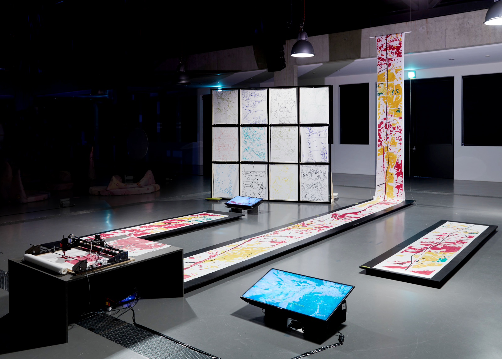
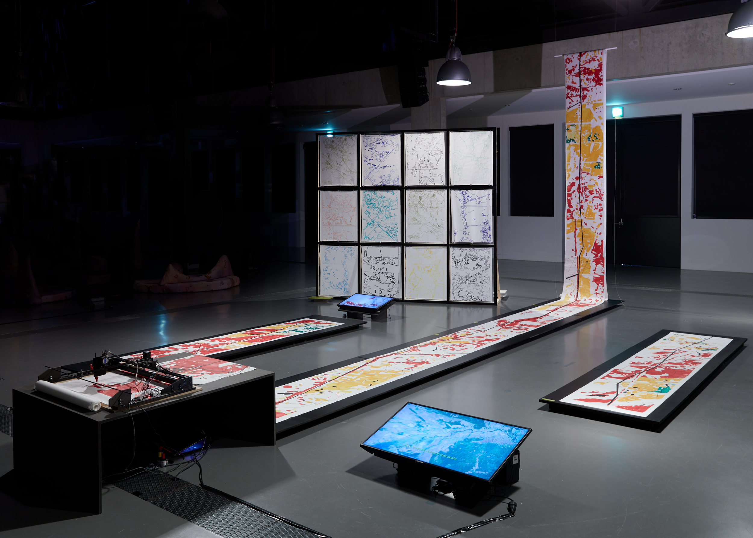
Mapping Uncertain Landscape : le Satelitte consiste en une machine à tracer qui dessine en continu des cartes du terrain ukrainien sur un grand rouleau de papier. Les images imprimées proviennent d'EOS SAT, un satellite commercial ukrainien de surveillance des cultures.
La carte 1, d'une longueur de 30 mètres, représente la zone la plus longue de la route, qui commence à la ville d'Ivankiv et se termine presque à la source de la rivière Teteriv. Date des données : 23.03.2023
Carte 2 : 3m de long, représente le tronçon de 10km. De la ville d'Orane à Zoryn Date des données : 23.02.2022
Carte 3 : 3m de long, représente le tronçon de 10km. De la ville de Zorane à Hornostaipil Date des données : 23.02.2023
La machine est construite de la même manière qu'un traceur à plume. Utilisant des pièces d'impression 3D ainsi que du bois et du métal, elle est équipée d'un circuit CNC. Elle fonctionne donc comme une machine à commande numérique. La possibilité d'ajuster les axes X et Y a permis à Sonya d'utiliser un plus grand format de papier. En plus de la construction d'un support spécifique pour les stylos et les marqueurs, Sonya a pu utiliser divers outils pour tracer et dessiner les cartes.
La carte 1 : 30 m de long représente la zone la plus longue de la route, commençant à la ville d'Ivankiv et se terminant presque à la source de la rivière Teteriv. Date des données : 23.03.2023
Carte 2 : 3m de long, représente le tronçon de 10km. De la ville d'Orane à Zoryn Date des données : 23.02.2022
Carte3 : 3m de long, représente le tronçon de 10km. De la ville de Zorane à Hornostaipil Date des données : 23.02.2023
Images satellites variées imprimées par la machine
Film de présentation du projet
Le projet a été développé dans le cadre du programme de vulgarisation universitaire d'EOS Data Analytics. Sonya a eu l'occasion d'utiliser leurs outils d'analyse de données géospatiales alimentés par l'IA. Sonya a eu l'occasion d'utiliser leurs outils d'analyse de données géospatiales alimentés par l'IA, en particulier pour les données agricoles généralement utilisées par les agriculteurs pour surveiller leurs champs.
Ce type de données sur lesquelles Sonya s'est concentrée est appelé NDRE (Normalized Difference RedEdge). Il s'agit d'un indicateur de l'activité photosynthétique d'une couverture végétale utilisé pour estimer les concentrations d'azote dans les feuilles des plantes au milieu et à la fin d'une saison. Il permet de détecter la végétation oppressée et vieillissante et est utilisé pour identifier les maladies des plantes.
En fin de compte, mon projet a un double objectif. Tout d'abord, il me permet de témoigner, une tâche ardue à laquelle s'adonnent quotidiennement les Ukrainiens. L'idée que quelque chose de traumatisant nécessite de témoigner, de voir et d'entendre constitue la pierre angulaire du journalisme. Cette responsabilité s'étend désormais aux artistes, aux concepteurs et aux travailleurs culturels en Ukraine. Les cartes et la cartographie nous permettent, en tant qu'artistes et designers, de continuer à témoigner de la brutalité de la guerre, même si c'est sans succès.
Deuxièmement, elle remet en question le besoin général d'homogénéité et de simplicité de la cartographie lorsqu'il s'agit de la représentation spatiale de la guerre. L'accent n'est plus mis sur les gains et les pertes de territoires, sur le rouge et le bleu, sur les territoires occupés et non encore occupés, mais sur la verdure et la végétation. Les herbes et les arbres, la croissance et la décomposition, les processus naturels qui sont perturbés par les actes de guerre. Mes recherches suivent les travaux de plusieurs universitaires ukrainiens, dont Asia Bazdy- rieva et Darya Tsymbalyuk, qui considèrent la guerre actuelle comme une nouvelle actualisation de l'impérialisme, opérant par effacements, l'écologie étant un autre niveau d'effacement sur lequel nous ne nous concentrons pas toujours. Mais en y regardant de plus près, nous pouvons comprendre beaucoup de choses sur la guerre elle-même. Ainsi que sur une éventuelle reconstruction ou guérison future.
ENG
Sonya Isupova - Mapping uncertain Landscape
Witnessing changes of the Ukrainian landscape: surveilling, tracking and targeting, diagramming, drawing, and redrawing the segments of Ukrainian terrain using a map-making machine.
Everything started with the map. Since the beginning of the full-scale Russian invasion of Ukraine, global news agencies, intelligence agencies, independent cartographers, and investiga- tive journalists have pored over the map. They all seek to create the simplest, most understand- able, and visually appealing map to explain the complex realities of this brutal, unprovoked war. Yet these maps are full of reductionist practices that tend to simplify and erase the reality of what they are supposed to represent. This project is a continuation on my master thesis “Mapping Uncertain Landscape”, where I analyzed Ukrainian modern cartography related to the war in Ukraine and compared various cartographic sources. Exploring the question of accuracy when mapping the uncertainties of war I could see the problems and possible alternatives to modern cartographic practices.
The installation explores the relationship between humans and machines, the map maker, and the map. Looking closer at the remote-sensing infrastructures, and their problematics. As well as questioning maps and mapping processes all in order to sense changes in the landscape that are occurring daily due to the current war in Ukraine. Sonya Isupova built a machine, a metaphorical satellite, hovering above the land, mapping the data with a limited amount of accuracy, transform- ing satellite images into maps of the territory.
When Sonya Isupova went to Kyiv in August of 2022, her eyes were peeled to the landscape. She needed the see, what has changed. In order to do that she built a map-making machine, a forever watchful eye: focusing on a specific location: this road between Ivankiv and the Belarus border, 50 km from Chornobyl’s Zone of Exclusion. 90km to Kyiv.
This particular location was chosen because it was along this road, on the 27th of February, that a con- voy of Russian troops was sighted by the Google Maps satellite. It marked the first instance in this war where non-military satellites were employed to observe the conflict. Russia’s full-scale invasion of Ukraine is being monitored by the watchful eyes of commercial satellites like no other conflict before.
Mapping Uncertain Landscape: the Satelitte consists of a plotter machine continuously drawing maps of the Ukrainian terrain on a large roll of paper. The images being printed take their data from EOS SAT, a Ukrainian commercial crop monitoring satellite.
Map1:
30m long depicts the longest area of the road, starting at the city of Ivankiv and ending almost at the headwaters of the river Teteriv. Date of the data: 23.03.2023
Map2:
3m long, depicts the stretch of 10km. From the city of Orane to Zoryn
Date of the data: 23.02.2022
Map3:
3m long, depicts the stretch of 10km. From the city of Zorane to Hornostaipil
Date of the data: 23.02.2023
The machine is built similarly to a pen-plotter. Using 3D printing parts as well as wood and metal as its core, it has a CNC circuit. As a result it func- tions like a CNC machine. Being able to adjust the X and Y axis allowed Sonya to use a bigger size of paper. As well as construction of a specific hold- er for pens and markers Sonya could use various tools for plotting and drawing the maps.
Map1:
30m long depicts the longest area of the road, starting at the city of Ivankiv and ending almost at the headwaters of the river Teteriv. Date of the data: 23.03.2023
Map2:
3m long, depicts the stretch of 10km. From the city of Orane to Zoryn
Date of the data: 23.02.2022
Map3:
3m long, depicts the stretch of 10km. From the city of Zorane to Hornostaipil
Date of the data: 23.02.2023
Variouse satellite images printed by the machine
Film as an overall introduction to the project
The project was developed as a part of the EOS Data Analytics Academic Outreach Program. Sonya had the opportunity to use their AI-powered geospatial data analytics tools. Specifically to agricultural data that is typically used by farmers to monitor their fields.
This type of data that Sonya focused on is called NDRE (Normalized Difference RedEdge) and is an indicator of the photosynthetic activity of a vegetation cover used to estimate nitrogen concentrations in plant leaves in the middle and at the end of a season. It allows you to detect the oppressed and aging vegetation and is used to identify plant diseases.
Ultimately, my project serves a twofold purpose. Firstly, it serves as a means for me to bear witness—an arduous task carried out by individuals in Ukraine on a daily basis. The notion that something traumatic requires witnessing, seeing, and hearing forms a cornerstone of journal- ism. This responsibility has now extended to artists, designers, and cultural workers in Ukraine. Maps and mapping serve as a means for us, as artists and designers, to continue this work of bearing witness to the brutality of war, even if unsuccessfully.
Secondly, it challenges the general need for homogeneity and simplicity in cartography when it comes to the spatial representation of the war. To shift the focus from territorial gains and losses, red and blue, occupied not-yet occupied territories, to the greenery and vegetation. To the grasses and trees, to growth and decay, natural processes that are being disturbed by the acts of war. My research follows the work of various Ukrainian scholars including Asia Bazdy- rieva and Darya Tsymbalyuk that see the current war as yet another actualization of imperi- alism, operating through erasures, ecology is another level of erasure that we do not always focus on. But looking closer at it can make us understand a lot about the war itself. As well as possible future reconstruction or healing.